Introduction
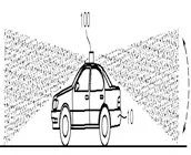
LiDAR mapping is a well-known technique used for quickly generating precise geo-referenced spatial information of the Earth’s form and surface. An early 1960s technology, Light Detection and Ranging LiDAR, creates high-resolution models with an ability to see through objects such as walls, trees or any such obstacle. Using LiDAR readings, distance between different objects in space can be determined with greater accuracy, and precision thus enabling construction of a 3D digital representation of the region. Light in the form of a pulsed laser is used in LIDAR. However, the use of light to measure distance has its own shortcomings such as the inability to see dark-coloreds objects, less-reflective paint colors and also more reflective, lighter colors. The present paper presents existing challenges in LiDAR, and the various solutions provided by researchers to address the same. It also covers the various applications of LiDAR, and key players, startups and collaborations in the space.
High power requirement[1]
Most automotive companies pride themselves on the high speed, resolution, and efficiency of their autonomous vehicles. Sensors in autonomous vehicles are required to work with high accuracy. As compared to other sensors, LiDAR’s power consumption is the highest, so the batteries may be drained very quickly. This will decrease the efficiency of a car’s battery which, in turn, will affect the vehicle’s range. Lower power efficiency means the customers must recharge, or even replace parts more often as opposed to radar or other types of sensors which are power-efficient. In addition, the performance of LiDAR sensors depends on weather conditions. LiDAR cannot capture images of surroundings accurately, especially in fog, snow, or dust conditions. LiDAR sensors and radar systems that can address such problems are still in the developmental stage. A recent patent application that discloses a solution to one such problem is presented below.
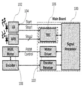 Carnavicom, in WO2022080586A1[2], has addressed the problem of high-power consumption. The system has a transmitter (102) for outputting light. A receiver (104) receives the light reflected from a target. A signal processing unit (100) measures distance of the target by using the received light. A time measurement unit (106) detects time difference between a time point at which light is emitted and a time point at which the reflected light is received. The signal processing unit changes resolution of the transmitter according to traveling speed of a moving object or a surrounding environment. The transmitter outputs the light at a resolution determined by the signal processing unit such that a number of laser outputs from the transmission unit are increased resulting in an increase in the resolution and the viewing angle range. The signal processing unit detects the time difference between a first stop signal having information on a transmission time point of light and a second stop signal having information on the reception time of reflected light at pulse period. The system can thus reduce power consumption by controlling the output resolution of the laser according to the traveling speed or the surrounding environment.
Thermal management
Power consumption of LiDAR is typically between 15 and 30 watts, and most of the input power is converted to heat. This leads to the heating up of its components such as the laser, detector, and scanner. Thermal management of LIDAR is critical as the heating up of components could cause problems. LIDAR is a high-cost component in autonomous vehicles, and so, proper thermal management is necessary. An example from a patent application is presented below.
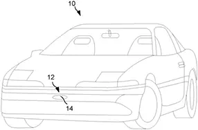 Magna Electronics, in US20210253048A1[3], has addressed the thermal management problem differently. A vehicular LiDAR sensing system (12) is equipped on the vehicle (10). The speed of the vehicle is determined continuously while a vehicle cruises along the road. An initial level of electrical power is provided to the LiDAR sensor based on the determined speed. A change in driving condition, such as speed of oncoming traffic relative to the vehicle is determined. The electrical power is then adjusted according to the sensing range of the sensor, in response to the change in the driving condition.
The power provided to the LiDAR sensors can be adjusted according to size or duty cycle of the associated fields of sensing. The system can operate appropriately to adjust power and thus control the temperatures of the sensors.
Difficulties in bad weather conditions
LiDAR systems emit laser pulses and determine the distance of a nearby object based on the reflective pulse that is returned upon contacting an object. So, when a common laser sensor attempts to detect objects in difficult weather, even raindrops or snowflakes are strong enough to send a reflective pulse back to the sensor and consequently hinder its performance. Due to this, traditional LiDAR systems are currently being applied only in controlled environments. However, modern radar systems perform well even in inclement weather conditions such as snow, fog, and heavy rain. Advancements in the strengthening of laser pulses, will enable effective usage of LiDAR sensors.
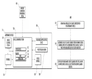 Uatc LLC has addressed the problem of bad weather conditions which is disclosed in its US patent 10173646B1[4]. Autonomous vehicle sensors may suffer from the presence of precipitation, debris, contaminants, or any environmental object which could interfere with the ability of the sensor to collect data. Occurrence of rain, snow, frost, or other weather-related conditions can degrade the quality of the sensor data. For example, raindrops, snow, or other condensation can collect on the lens or other components of a sensor (e.g., a camera or LiDAR sensor), thereby degrading the quality of the sensor data. Dirt, dust, road salt, organic matter (e.g., “bug splatter,” pollen, bird droppings, etc.), or other contaminants may accumulate on the sensor or adhere to it (e.g., on the sensor cover, housing, or other external component of the sensor), thereby degrading the quality of the sensor data. The invention involves determining a cleaning sequence for sensor cleaning units of an autonomous vehicle based on data indicative of a sensor condition, where the sensor cleaning units clean the sensors of the autonomous vehicle. The sensor cleaning sequence comprises a set of control actions to cause the sensor cleaning units to clean the sensors according to a certain frequency.
The method enables the sensors in an autonomous vehicle to be cleaned based on sensor conditions, thus allowing for safer operation of the autonomous vehicle. The method enables prioritizing cleaning of the sensors to detect increased accumulation of contaminants, thus efficiently using energy and liquid resources and reducing wear and tear of the sensor cleaning units.
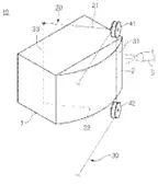
Hyundai Motor Co & Kia Corp, in US11433433B2[5], have provided a solution for addressing problems caused due to sticky materials adhering to LiDAR sensor. When a sticky material with high viscosity is attached to the surface of the LiDAR sensor, a conventional apparatus for cleaning a LiDAR sensor may fail to effectively remove the same. The inventive device (10) has a swivel frame (20) which is rotatably mounted with respect to the lidar sensor (1). A cleaning wire (30) is mounted on the swivel frame that includes a straight section (31) which contacts a surface (2) of the lidar sensor and a drive mechanism which permits the swivel frame to rotate. The rotation of the swivel frame allows the straight section of the cleaning wire to contact the surface of the LiDAR sensor. The straight portion of the cleaning wire is stretched to firmly contact the surface of the lidar sensor. The device effectively removes a blockage or a sticky material that is adhered to the surface of the lidar sensor. The device uses cleaning nozzle and the cleaning wire in combination or independently, thereby improving cleaning efficiency with regard to the lidar sensor. The number of rollers is reduced, and thus a relatively simple structure is created. The front surface of the lidar sensor is curved in order to increase the detection range. Device for cleaning lidar sensor is mounted on front bumper and roof of motor vehicle.
Bulkiness
Modern LiDAR sensors involve a spinning module on the top that is capable of detecting objects nearby. However, the whole system is large and it is difficult to reduce its size while maintaining high quality resolution. The large bulky traditional rotary LiDAR systems will inevitably lose their appeal if significant changes are not made to the structure of LiDAR.
Steep price of models and their maintenance fees
LiDAR being a fairly new concept, resources, technology and software required to construct LiDAR systems are sparse and limited. This leads to manufacturers pricing the materials extremely high especially because of their inability to produce them in large numbers. Basic models tend to cost between $10,000 and $20,000 while top-end models from companies such as Luminar and Velodyne can cost up to $80,000. Such high prices are limiting the commercial usage of LiDAR systems.
It is also important to take into account the cost of maintenance of a LiDAR sensor. Many of the initial prototypes launched by companies include multiple moving parts within the sensor that are prone to damage, especially when the vehicles travel on highways. Replacing the sensor as a whole is not an option and finding individual parts is not only difficult but also expensive.
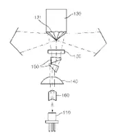
 Wikioptics Co., Ltd has addressed the problem of size and cost as seen in patent no.KR101687994B1[6] The system has a laser light source (110) for irradiating laser. A collimator lens (140) changes the laser irradiated from the source to collimated light. A micro lens array (120) is installed on the route of laser passing the collimator lens. A poly-pyramid mirror (130) is passed along omni direction. A beam shaping prism (150) is installed at the front end of the micro lens array for beam-shaping the laser. Direction of the laser irradiated on the outer side is detected by using specific equation including number of mirror facets (131) and field of view (FOV) of the lens array.
LiDAR lighting system used in an autonomous vehicle can also be used in a satellite for irradiating laser pulses on an object during meteorological measurement process or distance measurement process.
Some key manufacturers of LiDAR sensors are presented below:
Velodyne:
 Velodyne is one of the first innovators in the LiDAR industry. Founded in 1983, Velodyne quickly emerged as the leader. The company has produced several models with unique focus and function. Its two main products include Solid State LiDAR and Surround LiDAR. Solid State LiDAR includes Velarray M1600 and Velabit models capable of short and long-range detection respectively. These sensors can be easily incorporated into vehicles, machinery, and robots due to their less bulky size. Velodyne’s Surround LiDAR product line focuses more on the 360-degree aspect. These models are capable of detection in inclemental weather conditions and are usually incorporated in vehicles to help with mapping and detection of objects. Velodyne has participated in the DARPA Grand Challenge. Velodyne has won many awards for its outstanding achievements and contribution to autonomous, and unmanned systems. Its products have been adopted by industry leaders such as Google, Caterpillar, Ford, Baidu, Mercedes-Benz and Nikon.
Luminar:
 Founded in 2012, Luminar has produced efficient products that have made it an industry leader. The company has partnered with automotive giants such as Mercedes-Benz, and Volvo, which have incorporated Luminar’s LiDAR sensors into self-driving passenger cars. Luminar has released three main models namely, Iris, Hydra, and Sentinel. The models are very different from each other and have different capabilities. Iris is extremely small, lightweight, and is capable of incorporation into different vehicles. Hydra focuses more on highway object detection within 250 meters. The Hydra model also performs at an extremely high resolution and speed. Finally, Luminar’s Sentinel model, a collaboration with Zenseact, emphasizes safety and is being incorporated into upcoming Volvo models.
AEye:
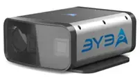 Founded in 2013, California-based AEye has focused on building safe and efficient LiDAR systems. Its 4Sight Intelligent Sensing Platform has introduced several advancements in the safety and efficiency aspects of LiDAR systems. AEye is addressing autonomy issues not only in the automotive industry, but also in infrastructure and trucking industry. While being a solid-State model, 4Sight is extremely advanced and is capable of detecting objects in all climates. 4Sight uses its advanced detection capabilities to provide safety in autonomous vehicles.
Opal by Lumibird:
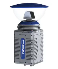 The Opal LiDAR system is a highly advanced model that is capable of performing unhindered during inclemental weather conditions due to its extremely high resolution of 300,000 points per second. The field of view of this model is highly advanced and it is possible to capture objects within 360°. This device is designed to assist in landing and takeoff during flights. Its ability to detect obstacles on the runway helps decide whether the area is clear and where to land the aircraft. The company is currently working on building a model of an autonomous aircraft that can fly with minimal pilot intervention.
Startups:
A few start-ups working on LiDARs are presented below:
HYBRID LIDAR SYSTEMS AG[7]
Hybrid Lidar systems, a German company established in 2018, has developed a patented LiSSA technology (Lidar for Smart Sensing and Automotive), that offers a resolution for 3D LIDAR by sensing horizontal position and distance. The goal of the company is to produce low-cost products with high efficiency. In order to save energy, this system takes the help of a scalable scanning matrix which offers high scanning speed.
The patented technology comprises hybrid Time of Flight (ToF) and photovoltaic (PV) technology. Aiming to replace existing large and bulky LIDAR sensors, Lissa, employs solid-state technology, and offers higher range, and accuracy. The company filed patents focusing on the speed of recognition of the objects, resolution (US20220179054A1) and image data (WO2021204968A1)
INNOVIZ TECH LTD [8]
An Israel-based startup established in 2016, Innoviz has developed LiDAR systems that are able to withstand inclemental weather conditions. The company’s effort to ensure safety has resulted in the creation of InnovizOne, a product that encompasses multiple technologies to track multiple objects in a vertical field of view. The company has expanded its offerings by applying the LiDAR systems to a variety of vehicles ranging from Robotaxis and trucks to industrial drones. The company has filed two patents focusing on controlling and deflecting laser beams to prevent eye damage (EP3999867A1 and US20220171031A1).
QLM TECH LTD[9]
Established in 2017 in the United Kingdom by Xiao Ai, Quantum Ligh Metrology (QLM) focuses on monitoring greenhouse gas levels through a Tunable Diode LiDAR gas sensor (TDLidar). This method of using gas for imaging and detection has been implemented in its Single Photon Lidar Imaging of Carbon Emissions (SPLICE) project and will be used to monitor the levels of gases such as carbon dioxide and methane. Its rapidly tunable diode LiDAR system disclosed in EP3956677A1 is capable of displaying output radiation values on a spectrum thus determining the extent of gas in a region.
SCANTINEL PHOTONICS GMBH[10]
Scantinel Photonics GMBH was founded in Germany in 2019 with the intent of creating advanced sensors capable of detecting objects effectively within a certain range. Its Optical Enhanced Array (OEA) system is able to accurately detect cars, persons and objects within the range of 300 meters. US20210316756 of Scantinel Photonics discloses a scanning device for measuring distance from an object using a light source to produce optical signals with varying frequencies. The optical signals are distributed simultaneously or successively onto optical output waveguides using an optical distribution matrix comprising optical switches and/or optical splitters (A1). The company has also developed a chip with the components of a LiDAR system designed to reduce weight, cost, and size of the system. This small chip can be added to several varying LiDAR systems and its versatility has drawn significant attention in the industry.
SILC TECH INC[11]
As the efficiency and capability of chips in the LiDAR industry remains unknown, companies like SiLC Tech have made several advanced 4D imaging chips (US11360213B2) that essentially function with the intent of letting machines see what the humans can. The startup, founded in the US in 2018, has created a cost-effective Frequency Modulated Continuous Wave (FMCW) sensor (US10788582B2) that is able to accurately image its surroundings while using limited power. As the first company to offer a commercially available version of this sensor with a built-in chip, its main applications are directed towards vehicular and mechanical robotics.
ZVISION TECH CO LTD[12]
Since its incorporation in 2017, Chinese startup Zvision has made significant progress in the LiDAR industry especially through its Micro Electro-Mechanical Systems (MEMS). The company’s unique laser radar system (CN215526114U) has a built-in wide field of view and ability to graph 3D images surrounding the sensors. Its MEMS system is able to function in a variety of weather conditions for the detection of long-range objects. The company is in partnership with some automotive companies which are evaluating Zvision’s products in their vehicles.
Collaborations:
Interesting collaborations are observed in the area of LiDAR.
- COLLABORATIONS OF OUSTER LIDAR WITH ACADEMIC INSTITUTES
- Ouster LiDAR has collaborated with GRASP Lab and Kumar Lab at the University of Pennsylvania
GRASP lab is working with OUSTER to develop LiDAR sensors that can scan and navigate underground regions that may require attention in disasters and crises. Furthermore, Kumar Lab (a branch of the GRASP Lab) is working on an autonomous robot that is capable of navigating underground. It uses the Ouster OS1-64 sensor which is a high-speed sensor capable of mapping environments and surroundings within seconds and displacing clear and precise data. - Stevens Institute of Technology
The Robust Field Autonomy Lab at the Stevens Institute of Technology in New Jersey is incorporating machine learning into its LiDAR designs to improve resolution. The researchers are using the OS1-64 lidar model of OUSTER LiDAR to validate their algorithm on real-world data. The research team has been successful in viewing the precise 16-beam, 2D data displayed by the OS1-64 Ouster LiDAR model. The team is confident that their design is capable of mapping more challenging environments including densely populated areas. - Mississippi State University (MSU)
At The Center for Advanced Vehicular Systems at MSU, the research and design team has created a supercar that is fully autonomous and entirely electric. This individual project is a small part of the entire HALO project which is working on over 300 tasks that include LiDAR in many different applications. Specifically, the HALO team believes that autonomous vehicles with LiDAR have the potential to exceed human capabilities in off-road environments where driving is difficult. Their supercar has three Ouster LiDAR systems, all built with their own individual focus. The goal of the project is to expand the use of LiDAR from urban and rural areas, to environments where the average human may find difficulty in driving.
- Ouster LiDAR has collaborated with GRASP Lab and Kumar Lab at the University of Pennsylvania
- COLLABORATION BETWEEN DSPACE AND CEPTON[13]
Cepton and dSPACE, the two LiDAR giants have worked together for easy incorporation of LiDAR into autonomous vehicles. The two companies have created an extremely small new sensor with an advanced driver assistance system. This sensor follows Cepton’s solo project titled Nova. The collaborative project uses the same software as Nova and requires extremely low power with a wide field of view. The collaborative product will allow autonomous vehicles to analyze their surroundings at an improved speed and resolution.
Applications of LiDAR:
1. Vehicle
LiDAR is being incorporated into the current wave of autonomous technology within vehicles. Many LiDAR systems, whether they are large models or a chip, are capable of calculating depth, and tracking objects. Automotive giants like Tesla and Toyota are incorporating LiDAR technology into their cars. Companies are hoping to create an influx of self-driving cars that require little to no human interaction and the capabilities of LiDAR is expected to fulfill such requirements. LiDAR being incorporated into vehicles is evident in Google Street View. Through rotating LiDAR sensors, Google Street View cars are capable of converting their surroundings into life-like images that we currently use every day in features like Google Maps.
2. Medical
LiDAR is a relatively new concept in the medical industry, and is still an emerging area. However, it has high potential for use in a variety of applications. LiDAR that has been tested in smartphones to help with diagnosis and tracking symptoms. The United States Navy filed for a patent (US20040019282A1) on LiDAR that would be capable of detecting cancerous tumors within the human body. The use of LiDAR in prosthetic and orthopedic applications may prove to be useful. LiDAR’s ability to perceive depth could very well help save many lives.
3. Aerospace In recent years, LiDAR has become extremely useful in the aerospace industry whether it be in-flight for pilots, or flight tracking in the control center. LiDAR can not only measure distance and map the surroundings, it can now even detect volcanic ash, turbulence and microburst in aviation. Additionally, in warfare, military planes use LiDAR technology to detect the enemy and map out the structure of their camp to help with their plan of attack. With the emergence of drone technology, several militaries are using LiDAR to map out the terrain of the battlefield and strategize points of entry. Aerospace LiDAR is still in its infant stage, but in future, it will become extremely useful in defense applications.
Conclusion:
LiDAR has become an integral part of autonomous vehicles. Progress with LiDAR’s sensors will make them more and more accessible and affordable over the coming years. LiDAR has demonstrated that it is capable of contributing to many applications outside of autonomous mobility. Aerial technology, geology, and topography are areas industries that could advance greatly with the help of LiDAR. From rotating sensors to miniscule chips, LiDAR is still evolving and only with time can one predict the applications that will use LiDAR sensors.
References:
- Lidar
Source - Lidar system capable of reducing power consumption and operation method thereof
Source - Vehicular sensing system with variable power mode for thermal management
Source - Sequential sensor cleaning system for autonomous vehicle
Source - Apparatus for cleaning LiDAR sensor
Source - LIDAR light-emitting system
Source - Hybrid Lidar Systems AG> LiSSA: Lidar for smart sensoring
Source - Innoviz
Source - Qlmtec
Source - Scantinel
Source - Silc
Source - Zvision
Source - dSPACE and Cepton Partner to Provide 3D Lidar Simulation for ADAS and Autonomous Applications
Source - Google Street View
Source
Disclaimer:
- This document has been created for educational and instructional purposes only
- Copyrighted materials used have been specifically acknowledged
- We claim the right of fair use as ascertained by the author
Posted Date: November, 2022